Mapping the ground truth of artisanal mining.
IPIS is an independent Antwerp research institute whose mine-site mapping and incident-monitoring infrastructure, built over more than a decade in eastern DRC, now reaches the cobalt copperbelt. Its Kufatilia system was extended into Lualaba, the heart of artisanal cobalt, in 2023.
Visit ipisresearch.beA research institute, not a programme.
IPIS (International Peace Information Service) is an independent, non-profit research institute based in Antwerp. Its stated mission is to provide tailored information, analysis, capacity enhancement and policy advice to actors working toward durable peace, sustainable development and human rights. It works across four areas: Natural Resources, Business and Human Rights, Conflict Mapping, and Arms Trade and Security.
Only the Natural Resources programme is profiled here. Since 2009, IPIS has built the most detailed open map of artisanal and small-scale mining in the DRC, sending field teams to geolocate sites and record who works them and under what conditions. That work began with the 3T minerals (tin, tungsten, tantalum) and gold of the east; what makes it matter to this Hub is that the same methodology and monitoring tools have since been extended toward cobalt.
The honest scope: IPIS does not yet publish a mine-by-mine map of the copper-cobalt belt the way it does for the Kivus. Its cobalt footprint is its incident-monitoring system Kufatilia, active in Lualaba since 2023, and a focused set of cobalt due-diligence and EU-regulation analyses, on top of a field method built to map exactly this kind of sector.
A map, a monitor and an evidence base.
It maps mining sites
Field teams geolocate artisanal sites and record the minerals dug, worker numbers, women’s and children’s presence, armed-actor interference, roadblocks and traceability status, in an open database of over 3,400 sites.
It monitors incidents (Kufatilia)
A community reporting system that logs accidents, violence and environmental harm linked to mining, now covering the cobalt province of Lualaba alongside the eastern provinces.
It analyses due diligence
It compares cobalt and 3T sourcing, assesses traceability schemes, and tests them against the OECD Due Diligence Guidance that underpins responsible cobalt.
It informs EU regulation
It brings DRC field evidence to the EU Battery Regulation, Critical Raw Materials Act and Conflict Minerals Regulation debates as they reach cobalt.
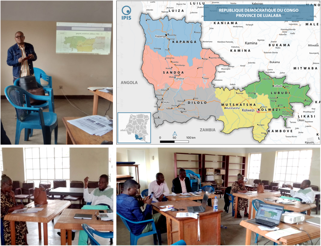
What the mapping looks like.
IPIS publishes its data as open, interactive webmaps and dashboards. Below: the flagship eastern-DRC artisanal-mining webmap, and the March 2023 Kufatilia training in Kolwezi that opened incident monitoring in the cobalt province of Lualaba.
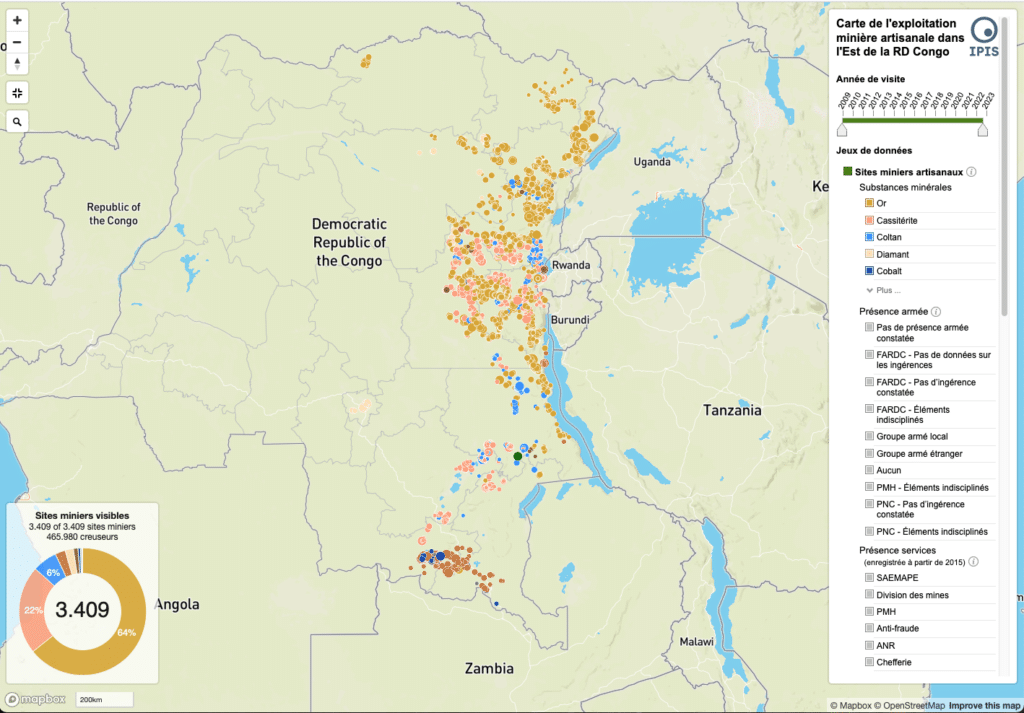
The live webmaps and the Kufatilia incident dashboard, which shows Lualaba, are linked under References below. The copperbelt is currently covered through incident monitoring, not mine-site polygons.
What can be verified.
Site counts cover eastern DRC (3T and gold); as of June 2023 the database held 6,955 total site visits. The Lualaba expansion is incident monitoring (with CSOs ADDH, AFEDECO and IBGDH), not a mine-site census. Figures: IPIS.
Public donors and a local network.
IPIS’s mineral research is grant-funded and delivered with local civil-society networks. The cobalt-relevant work draws on EU, Belgian, Dutch and US public funding.
 European Union
 OECD
OECDDonors and partners vary by project; those listed back the mapping, Kufatilia and due-diligence outputs. The three Lualaba CSOs run incident reporting on the ground around Kolwezi, Mutshatsha and Lubudi.
Every source, linked.
The primary IPIS pages, datasets and cobalt-relevant outputs behind this profile.
From the Kivus to the copperbelt.
- 2009
IPIS begins systematic field mapping of artisanal mining sites in eastern DRC.
- 2010
It contributes implementation findings to the OECD and ICGLR due-diligence pilot in the Great Lakes, the template later applied to cobalt.
- 2018
IPIS launches Kufatilia, a community system for reporting mining-related incidents, in the eastern provinces.
- 2020
It publishes its first dedicated cobalt briefing, on child labour and large-scale-mining corruption in Katanga and Lualaba.
- 2021
A comparative analysis of cobalt versus 3T sourcing from the DRC is released with EurAc.
- 2023
Kufatilia is extended into Lualaba, with training for CSOs in Kolwezi: IPIS’s first operational presence in the cobalt zone.
- 2024
IPIS convenes a debate on Congolese cobalt, EU battery and raw-materials regulation, and direct investment.
A research backbone, reaching toward cobalt.
IPIS is active and independent. For this Hub it is best understood not as a cobalt programme but as the research and mapping backbone the cobalt debate borrows from: an open evidence base, a community monitoring system and a body of due-diligence analysis, built for the minerals of the east and now stretching toward the copperbelt.
Two honest caveats. First, IPIS does not yet map individual cobalt mine sites the way it maps the Kivus; the detailed copper-cobalt site mapping often cited (around 150,000 to 200,000 artisanal miners) is the 2019 BGR and Carter Center study, not IPIS. Second, IPIS stresses that its incident data is selective, not a statistically representative census. Its value is field-level ground truth and method, not a complete picture of the sector.
More initiatives, mapped and tracked.
IPIS is one of dozens of programmes and bodies shaping ASM cobalt. Browse the full register, or tell us what is missing.